Here are a few slide shows from some trips (mostly Caribbean). Many of the shots are found in the Dive Log, but again, I wanted to bring them together here.
 Georgia, Oct 08 Georgia, Oct 08 |
 Turks and Caicos, Mar 05 Turks and Caicos, Mar 05 |
| [singlepic=128,400,300] |
| The top of the wreck, covered with mussels and surrounded by fish |
Sunday we headed out to the stern of the Gulf Trade. The ship was a 430 ft tanker owned by (who else) Gulf Oil. When she was torpedoed in 1942, she broke in two. The stern section sank in 85 ft of water about 10 miles off Island Beach. The bow section floated closer to shore before sinking near Barnegat inlet. As a hazard to navigation, it was leveled.
The superstructure of the wreck still has about 20 ft of relief. Brandon tied us into the top making it an easy point of reference. On the top deck cunners, tog and sea bass swim in and out of the holes in the deck, nibbling at the mussels that grow there. Inflatable Water Slide A few feet away are two large boilers, still standing up the sea’s destructive forces.
| [singlepic=124,400,300] |
| Mooring bits and scup |
Once off the superstructure, the debris field stretches out over a wide area. Here small pieces of debris provide hiding places for lobster and fish. Still within the shadow of the wreck, a pair of large mooring bits stand upright in the sand. A large school of scup surrounded the area. The school prevented my camera from focusing on them.
Over by the boiler was another visitor from out of town. A butterfly fish darting around the wreck, looking very out of place. This is the third one I’ve seen in as many days of diving.
| [singlepic=127,400,300] |
| Engine |
Before long Brandon showed up and we started taking pictures of the large engine and boilers. Along with other bits and pieces of the wreckage that caught our eyes. A large trigger fish swam by but was not waiting for his picture. However, the dog fish that swam by a few minutes later came within a few inches of the lens.
With the great conditions, it was hard to end to dive. I just have to figure out how to bring the camera and the pole spear on the same dive. No task loading there!
| [singlepic=136,400,300] |
| View from the forward hold |
Saturday The Scuba Connection filled the boat with a charter to the Pinta. The Pinta was a freighter that went down in 1959 after a collision. The wreck lays on her port side at a depth of 85ft. Her cargo of wood timbers is still visible, strewn out on the sea floor. Frankie tied us in near the bow of the wreck. The wreck is split into two sections . The bow and stern provide over 20 foot of relief, and the holds are open for easy access.
| [singlepic=137,400,300] |
| Much of the wreck is covered in mussels |
Most of the people on board were just happy to get out diving this time of year. I was hoping for some more of that great visibility we’ve had the last couple bouncy castle for sale of months. Reports soon came back that there was 40-50 ft visibility, 58 degrees, and no current or surge on the wreck. The ride out had been a little bumpy, with a swell from the south, so this was great news. I jumped in with camera in hand and great expectations in my heart.
| [singlepic=138,400,300] |
| Starfish feed on the mussels |
When I hit the bottom I was a bit disappointed. The vis had dropped to 20 ft, and it was quite dark. There was a very slight surge, so the dirty water must have come from elsewhere. There were lots of sea bass around, and cunners swimming about. In many places the wreck is covered in mussels. Then there are bare spots where the star fish have cleaned them off. The remaining mussels are intermixed with anemones and monofilament.
| [singlepic=135,400,300] |
| The cargo of wood timbers |
I tried for a few shots out in the sand, hoping that away from the wreck the vis might be a bit better, but this did not seem to make a difference. The dim light also made it difficult to focus the camera. On the other hand, inside the wreck the vis was not bad. I was able to squeeze into the forward hold, and see the wood timbers stowed there. The upper decks have rusted away leaving a skylight effect.
| [singlepic=133,400,300] |
| Visitor from out of town |
On the way back to the line I was again surprised to see a lonely butterfly fish f littering about the wreck. I approaching the top of the wreck I was greeted by a pair of antenna connected to last nights dinner.
| [singlepic=111,400,300,,left] |
| The bow of the Chaparra |
Chapara November 1, 2008
Summary:
57 degrees top to bottom
50+ ft of visibility
Lobster, tog, sea bass, and dog fish.
NOAA was calling for a front to go through and swing the winds around from southeast to northwest. If all went according to plan, it should be an nice day on the water. When we pulled out of the inlet the conditions seemed better than the forecast, but as we got further out, the south east swell started showing. With our destination, and the wind coming from another direction, we were taking them on the beam, even at anchor. The swell was not big, but caused a lot of roll.
| [singlepic=110,400,300,,left] |
| Solitary boiler out in the sand |
Once Chris had us tied in, everyone started rolling in. Before long Chris was up with a report on the conditions. Dark, but clear on the bottom, and dog fish circling the line. Roger and I jumped in as the passengers started to surface.
Given the logistics, I opted for one long dive rather than two short ones. With camera in tow, I dropped down into the water. The dogfish were there just as bouncy castle for sale Chris had noted, however, they were not hanging around for pictures. The descent was murky, but opened up about 30 ft off the bottom. Chris had us tied into the prop shaft, but the prop is long gone.
| [singlepic=119,400,300,,left] |
| The other two boiler surrounded by fish |
Schools of juvenile sea bass circled the area between the three large boilers. Larger fish could be seen darting in and out of the boilers, and out from under the deck plates. The wreck lays on the starboard side with the bow section about 50 ft off in the sand. The skin of the ship is disappearing with time, leaving only the ribs jutting out of the sand. Here lobster, sea bass, and tog take refuge.
Once the rest of the divers were gone, the fish started to come out of hiding. There were a few large tog and a couple of trigger fish hiding in the boilers.
| [singlepic=109,400,300,,] |
| The port anchor still in the hawse pipe |
The bow section was covered with fish. Again schools of juveniles, as well as some larger sea bass and tog hiding in between the ribs. The last bulkhead of the bow section looks to have housed the deck winch for lifting the large anchor. On the other side, draped in line, the large port anchor can be seen still in the hawse pipe. Down at the bow dogfish cruised by regularly, checking for a quick meal. Now they didn’t seem to mind posing for the camera.
| [singlepic=118,400,300,,] |
| The skin falling away |
With the warm bottom temp, and lots to see, the time went quickly. Looking at my bottom timer, it had already been 2 hours, and it was time to head up. The other divers were beginning to show up again, and the fish went back into hiding.
Back on the surface, the rollers had died down nicely. It seemed like a completely different day. Chris jumped in with directions to the trigger fish, and plans to pull the hook. We were soon underway. Another Great day of diving.
The Independence II headed out this week on another wreck exploration trip. Captain Dan Bartone had obtained some promising hang numbers a few weeks back. They were located within a few miles of three known Black Sunday wrecks, and warranted further investigation. We’ve tried to get out a few times, but Neptune had his own ideas. This week the weather cooperated. Dan assembled some of the usual suspects (Dive Marshal Bill Trent, Richie Kohler and Dave Oldham), and headed over 50 miles offshore to check them out.
We arrived to sunny skies and clear warm water. Bill and Richie jumped in and tied in to the wreck in 230 fsw. The report came back that the current was ripping the whole way down to the wreck. While Richie swam along the wreck in an attempt identify her, Inflatable Water Slide Bill had other priorities, and completely filling his bag with lobster. Quite literally, one more lobster, and the bag would not close.
Dan and I splashed to check her out, and pull the hook. With the reports on the strong current, I opted to leave the camera topside. This was a good call, as the decent was hand over hand all the way down the line. We reached the bottom to find 40+ ft of vis, 47 degree water, and reasonably ambient light for this depth. We were tied into the bow winch with her boiler near by. What appeared to be the bowsprit could be seen a short distance off in the sand. This and other structures showed evidence that she was a sailing ship. We were not able to make it to the stern, given the current and the alloted time, but she appears to be over 150′.
We were quickly out of time, and had to get back to pull the hook. Dan and I spent the next hour+ decompressing in the 65 degree water. It felt comfortable to me, but Dan had a leak in his drysuit, and was chilling quickly at 30′. We got on board and headed back home.
 |
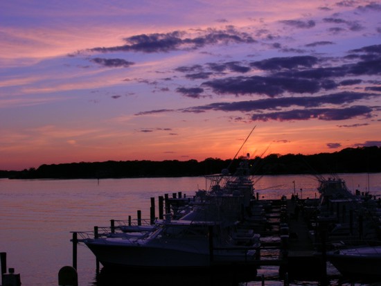
| Sunset at Clark’s |
On the way back we all discussed the nature of the wreck. She’s a low lying, wooden sailing vessel which means that identification will require some digging. Her position is within 10 miles of the charted position of three other Black Sunday wrecks. Could she be one also? Only time will tell!
We arrived home to a beautiful sunset, and hot lobster dinner!